GEOLOGY & GEOGRAPHY OF THE LOIRE
THE MOTHER ROCK
At the foot of Mont Gerbier de Jonc, a not-very-imposing-looking volcanic mountain in the highlands of the Ardèche region of France, three springs bubble out of the earth. These springs, or sources in French, come from the aquifer hidden under the crust of this mountain, and flow constantly, thanks to the high water table in the area. Formed 8 million years ago of slow-moving phonolite lava, the mountain is not a warm and inviting mother, but a mother nonetheless. Because Mont Gerbier de Jonc, with the three springs that break through the earth at her base, is the mother of the Loire.

Photo by M. Dupont
As these springs converge farther down the valley, they form what can generously be described as a brook. Standing beside it, it’s hard to imagine that this little creek will pick up steam for 629 miles, and eventually flow gracefully into the Bay of Biscay in the Atlantic ocean, just to the west of Muscadet. As it travels mostly north and then west, the Loire drains almost 50,000 square miles, fully a fifth of France. The Rhone might be deeper, the Seine might have been painted by Monet, but the Loire is the longest, and historically most important, river in France.
Holding the claim as the last wild river in Europe (as there are no dams on its main course), the Loire is no longer the deep and easily-navigable river that the Vikings rowed up in 853. For much of its journey, it actually appears relatively shallow, and the French government’s recent plan of returning the Loire to its natural state by destroying many of the dams on its tributaries appears to be working. The populations of river trout, pike, eel, and sturgeon are growing, and wild boar and deer can often been seen on its banks, especially after it starts the slow turn to the west at Sancerre.
For roughly the first third of its journey, the Loire doesn’t see many vines. It cuts slowly through narrow gorges until it reaches the first real navigable section of the river at Roanne, with its Pinot Noir and Gamay vines that make up the delicious Côte Roannaise wines of the area. From there, until it reaches the Atlantic, it flows through (or near) 87 appellations, if you count the Vin de Pays and VDQS (vin délimité de qualité supérieure) systems in addition to the AOP’s (appellation d’origine protégée). Some of those appellations begin on the banks of the Loire, such as Vouvray and Montlouis, which face off across the river from each other just to the east of Tours. Others can be found straddling her tributaries, such as Chinon on the Vienne, and Saint-Pourçain which is on the Sioule, a river that flows into the Allier, the Loire’s most important tributary.

The Loire near Saint-Martin-de-Fugères, about an hour’s drive from Mont Gerbier de Jonc. Photo by A. Aubry
The Loire river itself is generally classified into three zones (as distinct from how we classify its wine regions, which we will discuss shortly). The Upper Loire (actually the most southern of the zones) extends from Mont Gerbier de Jonc to the point where the Allier joins the Loire, about an hour’s drive south of Sancerre. The first part of this upper section of the Loire looks more like a mountain stream than the wide river you would see in, say, Saumur. It starts to spread out to the south of Roanne and becomes navigable as it reaches the alluvial plains formed at the base of the high country. The area of the Loire from its confluence with the Allier to where the Maine river joins the Loire is called the Middle Loire, and includes the vast bulk of the wine regions of the Loire Valley. This section passes through the storied chateaux country, and is the area generally referred to with the nickname, “Valley of the Kings”. Finally, the Lower Loire extends from the Maine river’s confluence with the Loire to the estuary at the end of its path toward the Atlantic ocean.
When speaking about the Loire wine regions, however, the Upper Loire refers to all wine regions from the source of the Loire to the edge of the Touraine including appellations in the Centre (named because this region is the center of France) such as the famous appellations of Sancerre and Pouilly-Fumé. The Middle Loire covers the Touraine, Saumur, and Anjou regions and represents the bulk of the appellations. The Lower Loire refers to the Nantais and the appellations near the end of the Loire, as it stretches toward the Atlantic Ocean.

There are several wine regions that are grouped with the Loire that bear, in some cases, only a passing resemblance to the heart of the Loire Valley. The Fièfs Vendéens, for example, is a full hour’s drive south of the Loire, but is still attached to the Loire wine region. A second river called the Loir (note that this river is masculine in French while the river Loire, with an “e”, is feminine) snakes through a more rural area to the north of the Loire.
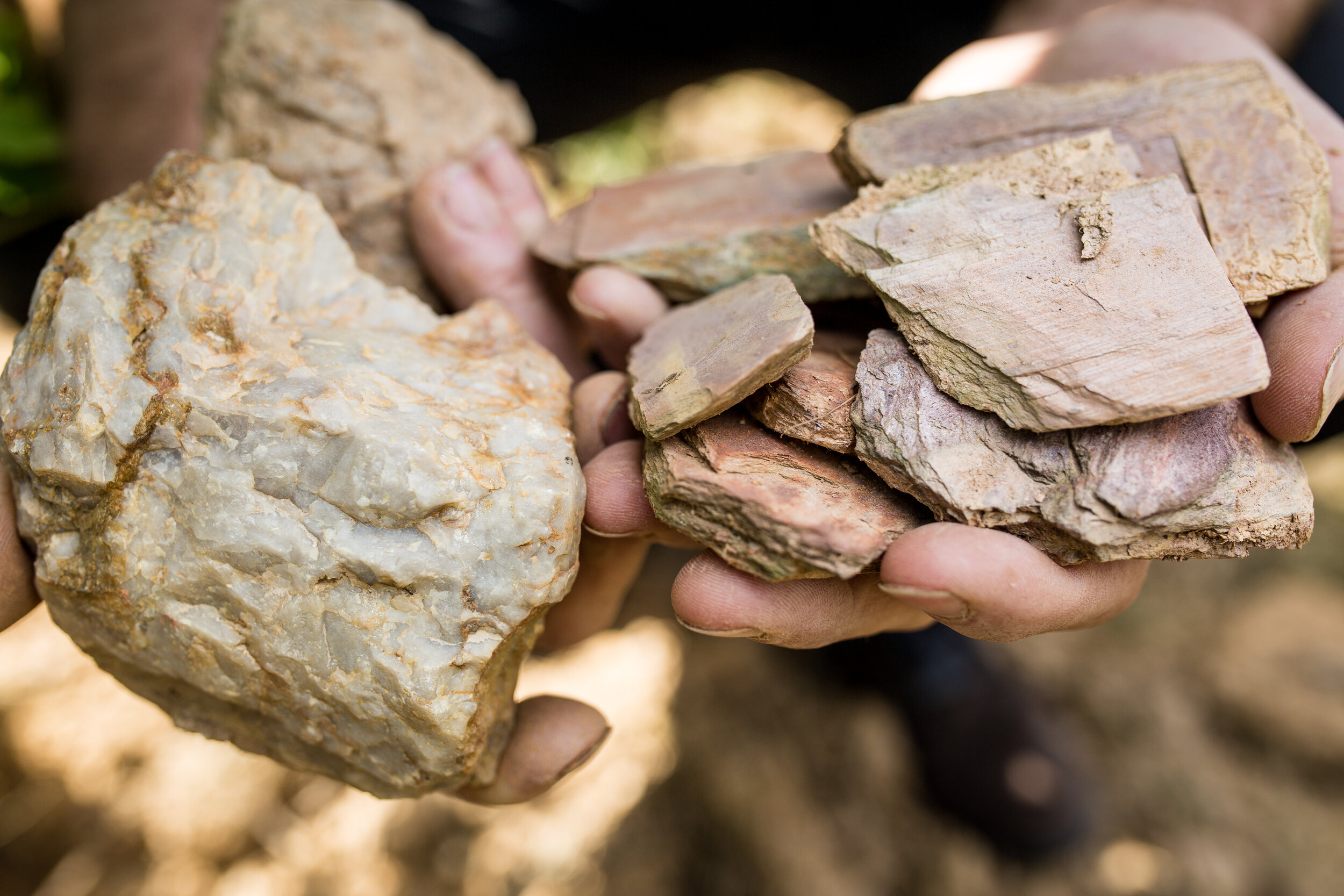
Why are there over 80 appellations in the Loire Valley? Because each region produces wines that are distinctive and different from the other regions, even if using the same grape. The chenin blancs of Vouvray, produced on soft white tuffeau limestone, are dramatically different in style and weight from the chenin blancs of Savennières, an appellation in the Anjou where the earth is covered with slate and other metamorphic rocks. As any student of wine will tell you, the soil and rocks that a vine grows on has a lot to do with what the wine will eventually taste like.

Chalk caves dug by prisoners at Louis de Grenelle, Saumur
And in the Loire, the bedrock is not only underground, but above ground as well, in the form of limestone peasant villages, magnificent chateaux, and regal manor houses. In general, the rock that is in the vines is the rock with which the village next door was built. The vines, the villages, the chateaux, the caves, and sometimes, the industries, are tied together today by what happened millions of years ago. To understand why the wines taste the way they do and why they are different from each other, to understand the stories of how prisoners came to be be hauling giant blocks of limestone out of quarries to build castles, to understand the past and the present of the Loire, you have to talk about rocks. So here we go.
HOT LAVA, COOL OCEANS
If you have already read the History of the Loire page, you will have remembered that the Loire began as two distinct rivers. If you haven’t, here’s a summary.
It is believed that the Loire river was formed when two ancient rivers were joined together during the uplift and formation of the Paris Basin (more on that in a minute). The first, what is referred to as the paleolithic Loire, actually flowed north and joined the Seine, the mythical river that now flows through Paris and into Normandy. The second began as a trickle in the region we now called the Giennois, about an hour’s drive northwest of Sancerre, and flowed to the west roughly along its current course. During the tumultuous formation period of the Paris Basin, this second Loire river caught and wrangled the paleolithic Loire (sometimes called the Loire Séquanaise, or “Seine Loire”) into one large river that spawned the valley as we know it today. The riverbed of the former Loire Séquanaise is now occupied by the river Loing, a tributary of the Seine that begins about an hour northeast of Sancerre and flows into the Seine just east of Fontainebleau.

The Loire river, as it stands today, flows through three major geologic regions. Beginning in the Massif Central, it flows to the north into the Paris Basin, and then into the Massif Armoricain just east of Nantes and Muscadet. Even though we can’t see below the surface, these three regions just feel different from each other, in no small part because the rock used to build the towns and villages is different in color, shape, and size. The climate, as well, differs dramatically from the beginning of the Loire to the end. The Massif Central feels more like the northern Rhone, with a decidedly continental climate. Because it is mostly in the highlands, the vegetation is more mountainous. The Massif Armoricain is much more humid and benefits from an oceanic climate with cooler days and nights.
THE MASSIF CENTRAL
Let’s begin with the Massif Central, since that’s where the story of the Loire begins. A massif, by the way, is simply a topographically-high crust of the earth, often bound together by fractures and deep crevices. This part of the crust can be moved by tectonic shifts which often result in rocky mountains and hills being pushed out of the earth. The Massif Central is one such massif that, as you might have guessed, is in the center of France. It covers about a sixth of the surface of the country. Much of the massif lies between 2,000 and 3,000 feet above sea level, much higher than the rest of the Loire Valley. These are the highlands of central France, with some peaks reaching as high as 6,000 feet.

Extinct volcanoes of the Massif Central
The enduring story of the Massif Central is the volcano. 450 extinct volcanoes have been identified in the region, some of which were still raging only 10,000 years ago. These volcanoes left behind giant quantities of lava which have formed into deposits of granite, gneiss, and schist (slate). This metamorphic rock covers three quarters of the region, mostly in the central and southern reaches. Much younger sedimentary deposits (from 150 to 200 million years ago) were formed over the remaining quarter of the area and exist mostly in the north, close to the Paris Basin.

Château de la Roche on the Loire river near Roanne
This is one of the most stunningly beautiful regions of France and has a decidedly rural character, with farming being one of the primary industries. There are parts of it, especially near Roanne, where I could believe that I was in central Italy, with Tuscan-looking homes built from the pink and sometimes red slate of the region. It looks like nowhere else in France. Beef cattle are raised in the northern parts of the massif, while dairy cattle dominate the central and southern areas. Some of the most famous cheeses of France are produced in the Auvergne (such as Bleu Saint-Nectaire and Cantal) and in the Grands Causses (Roquefort). The world-famous porcelain of Limoges is produced on the Massif Central. But you didn’t come here to learn about plates and platters; you’re here to learn about wine.
As you might imagine, most of the wines produced on these extinct volcanoes are grown on volcanic rock, some of it broken up at the surface, and some of it constituting a deep bedrock covered by a thin layer of loam. The appellations of the Côtes du Forez, Côtes d’Auvergne, and the Côte Roannaise are planted on this combination of granite, gneiss and slate. Farther north, the appellation of Saint-Pourçain is mostly planted on the younger sedimentary deposits of limestone and clay (hiding the volcanic rock well below the surface), and is more similar to Burgundy than to its Loire cousins to the South.
In the vineyard, vines planted on this volcanic soil don’t have the benefit of easy access to water. These soils drain very quickly and tend to shed organic material, with the drainage leaving behind a soil that helps to produce small bunches, small grapes, high acid, and low to medium ripeness in the fruit. There’s often a distinct saltiness to the wines, perhaps due to the complex mineral balance in the rock. While some of the wines are fruity, many skew heavily toward savory notes.
THE MASSIF ARMORICAIN
If you’ll indulge me, let’s go from the beginning of the Loire to the end, as these two regions are quite similar in their geologic composition. The Massif Armoricain is named for the region of Armorica, the ancient name for the region between the Seine and the Loire covering the peninsula of Brittany and extending into Normandy. The Gauls first named this area, and the name appears on Roman maps, indicating that they used it as well. In geologic terms, the massif covers all of Brittany, western Normandy, several of the islands in the English Channel, and the western end of the Loire Valley.

The geology of the Massif Armoricain.
Like the Massif Central, the Massif Armoricain is made up of cooled lava from ancient volcanoes, with the oldest rocks thought to be 650 million years old. Unlike the Massif Central, the Armoricain is at quite low altitude, with the highest peak being only 1,368 feet above sea level. Granite, gneiss, schist, and other metamorphic rocks run in long bands on an east-west axis. The occasional pocket of younger sedimentary rock can be found, including a small area to the west of Rennes, and another to the south of Nantes. Volcanic rock is found just below this sedimentary rock of quartz, clay, and loess.

The Côte de Granit Rose at Ploumanac’h in northern Brittany
Even though part of the region is in the Loire Valley, it should, for all intents and purposes, be Brittany. Nantes was the historic capital of Brittany, and you can still see the black and white Breton flag flying in the area. Brittany, that mystical land of the Celts, with its Arthurian forests and Celtic granite funeral formations, can be a surreal place to visit. The coast is lovely, with small fishing villages dotting the landscape separated by huge expanses of volcanic rock, the most striking being the pink granite of the Côte de Granit Rose, one of the most beautiful and strange places I have ever visited. Farther inland, slate villages with Breton names like Plounévézel and Guilligomarc’h are scattered throughout the forests.
There are a few vineyards planted in Normandy and Brittany, but cider is king in both. The orchards are planted on this dense metamorphic rock, and apples with odd names like peau de chien (skin of the dog) are grown beside centuries-old slate barns. In both areas, it’s not uncommon to see cows grazing in the orchards.
Farther south, near the end of the Loire, is the dynamic city of Nantes. The vineyards of Muscadet can be found principally to the south of Nantes, but also to the east and northeast of the city. There is still a Breton feel to many of the villages, but it feels more integrated with the rest of the Loire. Geologically, this is the most diverse terroir I have ever seen in France. While it is almost universally made up of volcanic rock, the variety is staggering, even within the same village in Muscadet. Granite, gabbro, gneiss, orthogneiss, mica schist, amphibolite, and serpentinite can all be found within a 20 square mile area as these east-west bands, in many cases, are quite thin. As a result, Muscadet wines can be quite different from village to village and site to site.

A wall of granite with Muscadet vines growing out of the top in Château-Thébaud
The Massif Armoricain also stretches east to include the western reaches of the Anjou, including the appellation of Savennières, and many of the famous dry and sweet wine villages south of the Loire. In wine terms, this area is called the Anjou Noir, as the vines are planted on the dark schist soils at the edge of the Armorican plain. The Anjou Blanc region, part of the Paris Basin, lies just to the east. Finally, the appellation of the Fièfs Vendéens can be found about an hour’s drive south of Nantes, hugging the Atlantic coast. The Vendée is a mixed soup of volcanic and sedimentary rock, depending on the village. Pink slate and quartz can be found in the same vineyard, often just a couple of kilometers from the Atlantic ocean.

Pink slate and quartz at Domaine Saint Nicolas, Fièfs Vendéens. Photo by Leigh-Ann Beverly
The same concept of quick drainage occurs on this volcanic rock as it does in the Massif Central. Maturity levels in Muscadet are generally quite low with a maximum alcohol percentage of 12%. The wines are high in acid and often extremely mineral, with a zip and verve that makes them excellent companions to a large range of dishes. In the Anjou Noir, the reds have a distinct mineral component and, like in the Massif Central, trend toward the savory. They can sometimes take some time to open up and can age very well. The whites are also very mineral, especially in cooler vintages, with high acidity and length.
THE BASSIN PARISIEN
As you walk across the Pont des Arts in Paris on a freezing February day, you would be forgiven for not believing that Paris, and most of the Loire Valley, was once a tropical ocean, palm trees and all. But it was, and you have only to walk through the vineyards of Sancerre, complete with millions of tiny oyster shells tilled up by tractors, to be convinced.

The Bassin Parisien (Paris Basin, in English) is a geologic region that borders the Massif Armoricain to the west, the Vosges and Ardennes mountains to the east, and the Massif Central to the south, and covers a third of France. As we defined the term massif before, it’s only fair to define a geologic basin. In this case, we’re talking about a sedimentary basin which occurs when the earth sinks and settles in a particular area, usually over millions of years, and is then filled with sediment over long periods of time.
Our story of this ancient basin starts 300 million years ago. The Massif Armoricain and the Massif Central were already partially formed, and were part of an extremely high chain of mountains, comparable to the Himalayas of today. A warm and humid jungle stood at the foot of these mountains and along the coastal plains, with early insects and amphibians already present. Over the course of tens of millions of years, these mountains were slowly eroded, the sediment rolling down the hillsides, over the jungle, and forming a giant arid desert of sediment. This huge, dry expanse of earth, the basement of the Paris Basin, slowly began tilting, allowing an ocean to creep over the basin from the east. It took 35 million years for it to advance 300 kilometers. The sand that had eroded from the mountains was washed onto the shores of this ocean, and the clay settled at the bottom.
Over many more millions of years, the sediment built up in successive layers, with the heaviest volume being deposited in the center of the ocean. As the weight at the center of the ocean increased, it sank deeper and deeper into the earth, and the edges and more shallow areas near the coast rose higher in the water, almost like a seesaw. This is important for our purposes as this raised earth near the edge now constitutes a large part of the Kimmeridgian band that runs from southern Champagne, through Chablis, and into the Loire Valley at Sancerre and Menetou-Salon. The ocean finally receded, leaving these layers of sediment to be covered by vegetation. But the ocean didn’t stay gone for very long, in geological time in any case. As the ocean came back, this time passing over modern-day Dijon and the Aube, it didn’t stop, and eventually joined the young Atlantic ocean. The mountains of the Massif Armoricain prevented it from invading Brittany, and the Massif Central stopped it from spreading farther south.

The center of the Paris Basin fell, and the edges stayed near the surface. Note the western end of the basin cutting the Anjou in half.
Over time, massive amounts of planktonic algae fell to the ocean floor and were compressed, forming chalk (craie in French). In some areas, the chalk was 2,500 feet thick. This, combined with the layers of chalk and clay from previous eras, meant that some of the basin was as thick as 10,000 feet. Finally, the ocean receded again, leaving a giant lake over the wine regions of Sancerre, Menetou-Salon, Cheverny, and others in the Centre. Eventually, with the disappearance of this lake, the Loire Séquannaise river appeared, and flowed into the Atlantic in what is now Normandy. It took two million years, but it was finally “captured” by a second river (which flowed roughly from Orleans to Nantes in today’s terms). The Loire Valley, as we know it today, had been born.
So you may be saying to yourself, “Cool story, dude, but what does any of this have to do with wine?”

Ocean bed Kimmeridgian limestone at La Tour Saint Martin in Menetou-Salon.
Well, as you drive from Puligny-Montrachet in Burgundy to Chablis, you’re driving through the Paris Basin, but you’re driving over different eras of the ocean’s history. As a result, the richer wines of Puligny-Montrachet and the mineral and bright wines of Chablis are incredibly different, even if they are made from the same grape. As you drive from Sancerre to the Touraine in the Loire, you’re driving through the Paris Basin, but you’re driving over different eras of the ocean’s history. As a result, the flinty sauvignon blancs of Sancerre and the more citrusy sauvignon blancs of the Touraine are incredibly different, even if they are made from the same grape. I could keep going, but I think you get my point. To learn the Loire, you have to study the ocean.
In Loire wine terms, the Paris basin begins on the western end of the Loire in the Anjou, where the deep limestone deposits help to produce delicious chenin blanc and cabernet franc wines. As you move east, this deep ocean floor limestone forms both the bedrock of the vineyards of the Saumur, Chinon, and Bourgueil regions, as well as the caves in which they are aged. Farther east, the limestone of Vouvray is softer, and is interspersed by bands of flint, while its cousin across the Loire, Montlouis, contains more sediment such as sand in addition to the clay and limestone. Farther east still, the Sancerre, Pouilly-Fumé, and Menetou-Salon wine regions are planted on the former coast of this giant ocean, with outcroppings of oyster-rich chalk jutting out of the earth at Chavignol, Sury-en-Vaux, and other villages. Just minutes away, the town of Sancerre is built on a massive hill of flint, separating it and its outlying villages by millions of years of geologic time.
NOW WHAT?
So what do we do with all of this?
We taste. And taste. And taste.

Taste a Sancerre from Domaine Claude Riffault on the crumbly ocean bed limestone of Sury-en-Vaux. Taste a Sancerre from Domaine Vacheron on the flint hillsides just 7 minutes away. Taste a dense and structured cabernet franc from Domaine de la Noblaie in Chinon on thick yellow limestone, iron coloring the ocean bed to a rusty hue in some places. Taste a cabernet franc from Saint Nicolas de Bourgeuil from Domaine Yannick Amirault on the sandy alluvial plains that covered up the ocean bed. Taste a volcanic cider from Johanna Cecillon in Brittany, planted on the Massif Armoricain. Taste a layered and complex Champagne from Françoise Bedel planted over the center of this former ocean in the western Marne.
Taste. Then send me a note and tell me what you think.
JD
